Guide
Sun Path Diagram
A sun path diagram - also called a sun chart or solar path diagram - is a flat map of where the sun sits in the sky for one location, plotted across the hours of the day and the days of the year.
In short: a sun path diagram plots the sun's azimuth (compass direction) and altitude (height above the horizon) for a given latitude. The arcs trace the sun's track at the solstices and equinoxes, so one chart tells you where the sun will be at any date and time - which is exactly the input a shadow study needs.
What a sun path diagram shows
A sun path diagram - also written sun-path chart, sun chart or solar path diagram - answers one question as compactly as possible: where is the sun in the sky, at this location, at any moment of the year?
It is drawn as a projection of the sky dome onto a flat circle, so every point on the chart maps to one direction and one height. Two coordinates describe any of them:
- Azimuth - the compass direction of the sun, measured around the circle from north (0°), through east (90°) and south (180°) to west (270°).
- Altitude (elevation) - how high the sun is above the horizon, from 0° at the outer edge up to 90° directly overhead at the centre.
The result is a family of curves. Each curve is the sun's track for a single day, and each is crossed by hour lines, so any intersection of a date curve and an hour line marks the sun's exact position at that moment.
How to read a sun path diagram
Reading a chart takes three steps: find the date, find the time, then read the angles.
1. Find the date
Most charts show three or four key arcs:
- Summer solstice (around 21 June in the northern hemisphere) - the highest, longest arc.
- Equinoxes (around 20 March and 22 September) - the middle arc, which appears as a straight line on many projections.
- Winter solstice (around 21 December) - the lowest, shortest arc.
Charts drawn for the tropics may add the two dates on which the sun passes directly overhead.
2. Find the time
Hour lines run across the arcs, usually at one-hour intervals. Architectural charts often group the summer months into a shaded overheating band and the winter months into a passive-solar band, so a façade can be judged at a glance.
3. Read azimuth and altitude
The point where your date and your time meet gives both angles:
- The angle around the centre is the azimuth - the direction the sun is coming from.
- The distance from the outer circle is the altitude - how high the sun is.
Those two numbers are exactly the sun vector a shadow calculation requires, which is why the diagram and an architectural shadow analysis are two views of the same data.
Why the diagram changes with latitude and hemisphere
A sun path is a property of a place, not of a building. Latitude sets how steeply the arcs tilt, and it decides whether the sunny side faces north or south.
- At low latitudes near the equator the sun climbs close to overhead and the arcs are tall and narrow.
- At mid latitudes the seasonal swing is large, so a façade that is sunny in winter may be almost end-on to the summer sun.
- At high latitudes the sun grazes the horizon for much of the year, and the contrast between a long summer day and a very short winter day dominates the design.
- In the southern hemisphere the chart is mirrored and the noon sun lies to the north rather than the south.
Getting the hemisphere right matters more than any other setting, because a chart read the wrong way round places the sun in exactly the wrong part of the sky.
Sun path diagram vs shadow study
The two are often confused, but they answer different questions.
- A sun path diagram describes the source: where the sun is, with no building involved.
- A shadow study describes the result: which surfaces that sun reaches once real geometry is in the way.
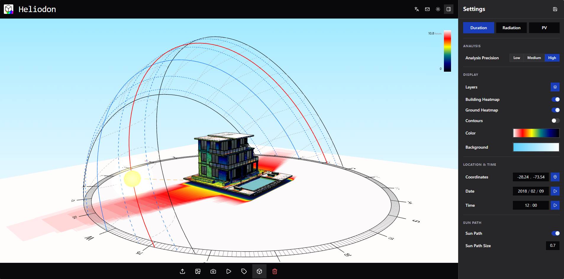
The bridge between them is shadow modeling, which projects the sun vector onto the 3D scene. Combine the two and the diagram stops being a reference chart and becomes a measurement of sunshine hours, overshadowing or solar radiation for a specific design.
Using a sun path diagram in design
Even without a 3D model, a sun path diagram supports quick decisions:
- Orientation: check when a façade, street or courtyard faces the sun.
- Shading: place horizontal louvres where the summer sun is high and vertical fins where it is low, so summer sun is blocked and winter sun is admitted.
- Landscape and public space: verify that a terrace or playground is sunlit during the hours people actually use it.
- Daylight: judge when direct sun will enter a room and when it is likely to cause glare.
Once those positions are projected onto a model, the same diagram becomes a shadow analysis with measurable sunshine duration and radiation.
Generating a sun path and shadows in Heliodon
- Import a model: open a .3dm, .obj or .dae file. It is parsed locally in your browser and never uploaded.
- Set the site: pick the location on a map so the correct sun path is used for that latitude and time zone.
- Scrub the sun: step through the day and the year and watch the shadows update in real time.
- Accumulate the result: turn the moving sun into sunshine-duration and shadow heatmaps, or into solar radiation.
- Export: save a screenshot, record an animation, or export an Excel report.
See the sun path on your own model
Heliodon is free and runs in your browser - no install, no account. Drop in a .3dm, .obj or .dae model, pick the site on a map, and watch the sun path drive real-time shadows.
Launch HeliodonFrequently asked questions
What is a sun path diagram?
A sun path diagram is a chart that plots the position of the sun in the sky for a specific latitude. Its horizontal axis is azimuth (compass direction) and its vertical axis is altitude (angle above the horizon), while the arcs trace the sun's path at the summer solstice, the equinoxes and the winter solstice.
How do you read a sun path diagram?
Find the arc for your date, follow it to the hour line for your time, and read that point against the centre: the angle around the chart gives the sun's compass direction and the distance from the outer circle gives its altitude. That single point is the sun vector used for shadowing.
Why does a sun path diagram change with latitude?
The sun's path depends on latitude. Near the equator the sun passes high overhead and the arcs are steep, while at high latitudes the sun stays low and the arcs are shallow, with long summer days and very short winter days.
Is a sun path diagram the same as a shadow study?
No. A sun path diagram describes where the sun is but contains no geometry. A shadow study combines that sun path with the 3D model of a building or city to work out which surfaces are shaded, and when.
Can I generate a sun path and shadows without CAD software?
Yes. Heliodon computes the sun path from the site coordinates in your browser, then projects those sun positions onto an imported .3dm, .obj or .dae model so you can watch shadows move through the day.